Geospatial surveys the solution to map West Africa

DAVID KHOZA Airborne geophysics is the most cost-effective method to produce a geological map that can be used in follow-up exploration


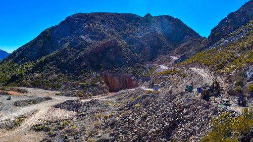
Airborne geophysics can cost effectively uncover valuable metal deposits in largely underexplored West Africa to allow for growth in the region’s mining sector, airborne electromagnetic technology pioneer Spectrem Air geophysics manager Dr David Khoza tells Mining Weekly.
“Countries like Ghana, Mali, Burkina Faso, Côte d'Ivoire, Guinea and Senegal are severely underexplored, owing to a lack of infrastructure because of funding, among other reasons,” he adds, noting that an increasing number of West African governments and exploration companies are using airborne geophysics to map natural resources because of its potential economic contribution.
In West Africa, Spectrem Air has most recently been involved in Ghana, Guinea and Mali. “We map the region for potential areas that could hold deposits using our geophysical technology. We have been quite busy, primarily in Ghana, but we have also done projects in Guinea, looking for gold,” adds Khoza.
He says airborne geophysics can rapidly collect accurate, high-resolution data across the entire region, producing a geological map that can be made available to mining companies and investors, and regularly accessed and used to identify areas for follow-up exploration.
Airborne geophysics is more cost effective, as it provides a tool for large reconnaissance surveys to be done rapidly, allowing for faster decision-making on which areas to explore further.
Spectrem Air’s geophysical technology is ideally suited to mapping complex geology, such as in West Africa. Therefore, the company is in regular discussions with junior explorers and miners in the region to deploy its systems there.
Some potential deposits in the West African region are largely inaccessible, and remote mineral-rich areas cannot be explored because of a lack of road infrastructure.
However, airborne geospatial surveys enable governments and exploration companies to understand the geological context of an area without having to physically inspect the grounds.
In January, Spectrem Air GM Louis Polomé stressed that not only is performing the measurements in the air a relatively cheap form of acquiring data but also results in faster decision-making.
In addition, the information is gathered nonintrusively, causing no disturbance to an area.
In Cameroon, Khoza says, the vegetation is so dense in unexplored areas that, if a company intends to undertake exploration through a drilling programme, it would need to construct roads to gain access to the site; geophysics allows for locating possible deposits from the air and results in intelligent and focused minerals targeting.
An airborne geospatial survey enables a geologist to assess a prospective area on a large scale, while a typical exploration area might be as big as 50 km2 to about 100 km2, he adds.
Airborne geophysical surveys use several different sensors attached to an aircraft to measure certain physical properties of rocks, including their density, magnetism and conductivity, he adds.
This information is, in turn, converted into a geological map that guides mining exploration programmes and assists in solving geotechnical issues and monitoring environmental elements such as underground water.
Depending on the initial discovery following the initial survey, smaller areas will be inspected using the applicable technology.
“When the presence of metals is suspected, for example, a magnetic survey will be conducted to collect high-resolution magnetic data followed by geologists’ assessment thereof and the mapping of the geology. Follow-up surveys will entail the collection of electromagnetic data,” Khoza explains.
He adds that extremely sensitive equipment is needed to locate rock units and mineral deposits when conducting surveys. Technological developments regarding geophysical equipment are focused on improving, for example, the sensitivity of geophysical sensors, and to make them as compact as possible to allow for their being used on unmanned aerial vehicles, or drones, for example.
In January, Mining Weekly reported that Spectrem Air, together with mining majors and main shareholders Anglo American and De Beers, was developing a superconductor magnetic gradiometer, known as Squid, that would greatly enhance the capability of the sensors used in airborne geophysical surveys.
Given the rate of technological advancements in electronics, Polomé noted that geophysical sensor technology had made significant improvements in terms of the resolution of the data collected, the size of the detectors, the sensitivity of measurements and the ease of deployment.
The company had been at the forefront of introducing new technology to its operations, and he highlighted that the gradiometer sensor would provide the next “big step” in the industry.
Polomé pointed out that the superconductive sensor was originally developed for military and medical applications, highlighting that Spectrem Air had secured exclusive use of the technology for application in mineral exploration from the Germany-based developers.
The company is now investigating the best way of deploying the technology on much more efficient and cost-effective platforms.
Article Enquiry
Email Article
Save Article
Feedback
To advertise email advertising@creamermedia.co.za or click here
Projects
Latest Multimedia
Latest News

Showroom

Columbus Stainless, based in Middelburg, Mpumalanga, is Africa’s only producer of stainless steel flat products. In addition, Columbus is the only...
VISIT SHOWROOM

Press Office
Announcements
What's On
Subscribe to improve your user experience...
Option 1 (equivalent of R125 a month):
Receive a weekly copy of Creamer Media's Engineering News & Mining Weekly magazine
(print copy for those in South Africa and e-magazine for those outside of South Africa)
Receive daily email newsletters
Access to full search results
Access archive of magazine back copies
Access to Projects in Progress
Access to ONE Research Report of your choice in PDF format
Option 2 (equivalent of R375 a month):
All benefits from Option 1
PLUS
Access to Creamer Media's Research Channel Africa for ALL Research Reports, in PDF format, on various industrial and mining sectors
including Electricity; Water; Energy Transition; Hydrogen; Roads, Rail and Ports; Coal; Gold; Platinum; Battery Metals; etc.
Already a subscriber?
Forgotten your password?
Receive weekly copy of Creamer Media's Engineering News & Mining Weekly magazine (print copy for those in South Africa and e-magazine for those outside of South Africa)
➕
Recieve daily email newsletters
➕
Access to full search results
➕
Access archive of magazine back copies
➕
Access to Projects in Progress
➕
Access to ONE Research Report of your choice in PDF format
RESEARCH CHANNEL AFRICA
R4500 (equivalent of R375 a month)
SUBSCRIBEAll benefits from Option 1
➕
Access to Creamer Media's Research Channel Africa for ALL Research Reports on various industrial and mining sectors, in PDF format, including on:
Electricity
➕
Water
➕
Energy Transition
➕
Hydrogen
➕
Roads, Rail and Ports
➕
Coal
➕
Gold
➕
Platinum
➕
Battery Metals
➕
etc.
Receive all benefits from Option 1 or Option 2 delivered to numerous people at your company
➕
Multiple User names and Passwords for simultaneous log-ins
➕
Intranet integration access to all in your organisation