Reality Modeling Drives Communication of Design Intent for Mobile River Bridge Project Bentley


This article has been supplied.
LumenRT Helps ALDOT Reduce Animation Production Time by 70 Percent on Second Highest Clearance Bridge in the United States
Proposing a Massive Bridge Solution
Extending 2,500 miles from Jacksonville, Florida, to Santa Monica, California, the Interstate 10 (I-10) is the southernmost transcontinental highway in the United States. It has seen steady increases in traffic volumes resulting in heavy congestion, especially passing through Mobile, Alabama, across the Mobile River through the George C. Wallace Tunnel.
Constructed in 1973 to accommodate 36,000 vehicles per day, the tunnel currently averages 73,000 vehicles daily, with peaks as high as 100,000 during tourist season. Compounding the issues of volume, the tunnel was designed with a geometry that results in the reduction of four lanes to two lanes through the tunnel, and a hairpin turn that reduces traffic to 25 miles per hours, causing bottlenecks along the corridor.
To alleviate congestion as well as provide a more direct route for vehicles transporting hazardous materials (HAZMAT), which are restricted from using the tunnel resulting in an hour-long detour, the Alabama Department of Transportation (ALDOT) is proposing a bridge and bayway widening project.
The proposed infrastructure design is a six-lane cable-stayed bridge, spanning approximately 2.75 miles with 215 feet of air draft clearance across the Mobile River to protect the maritime industry, making it the second largest clearance bridge in the United States, after the Golden Gate. The USD 850 million project includes widening 9.25 miles of causeway from four to eight lanes and requires ALDOT to obtain approval and buy-in from the Federal Highway Administration (FHA), environmental agencies, local government and businesses, and the community.
ALDOT immediately recognized that the only way to communicate the project’s potential and achieve crucial buy-in was to use reality modeling and visualization technology.
Reality Modeling Fosters Understanding
“There has been a lot of feedback from the public and stakeholders in Mobile, so we were tasked with creating a visualization of the project,” stated J.D. D’Arville, GIS/LRS Data Management Administrator at ALDOT.
The goals for reality modeling included:
• Illustrating visual impact of the project to the public and stakeholders;
• Presenting project details to obtain approval from the FHA for federal funding;
• Demonstrating the project’s positive impact on the local economy and city skyline;
• Revealing the project’s minimal environmental impact; and
• Rendering and simulating the Battleship National Park to show how it will be seen from the bridge and how park traffic will be accommodated.
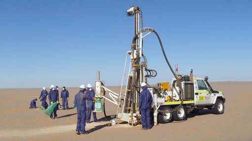
To realistically render the project in context, ALDOT collected GIS data and more than 600 perspective images using aerial LiDAR and helicopters fl own for the full 10 square miles of the project site to capture photos from 600 and 1,500 feet.
The project team used Bentley’s design and visualization technology, along with other third-party applications, to incorporate the mapped imagery into a 3D virtual model of the existing city skyline, corridor, and Battleship National Park. The team created a 3D conceptual model of the entire proposed project with realistic renderings and animations of the driving experience, as well as a 360-degree flyover to provide context from all angles around the city.
With Bentley LumenRT, ALDOT created an immersive LiveCube that was especially useful for public communication and understanding, allowing community members to view the model from any virtual perspective— from their home or business residence. “This software makes it easy for the general public to understand what exactly is taking place within a project,” commented Zac Cooper, ALDOT civil engineer and acting virtual design and visualization manager.
Leveraging Model Intelligence
The interactive 3D visualizations of the bridge and surrounding area were generated using a variety of input sources and models. OpenRoads enabled the team to design and model the complex geometry of the proposed project route along the corridor, while MicroStation® provided the renderings for the driving and flyover.
To manage, review, and process the 10-square-mile LiDAR data and aerial images collected, ALDOT relied on Bentley Descartes and Certainty 3D’s TopoDOT. Using Trimble’s SketchUp and Esri City Engine, the team modeled the existing city of Mobile including buildings and the proposed cable-stayed bridge.
Bentley LumenRT enlivened the project model with attention grabbing visuals, rendering cinematic quality in real time, animating models, incorporating digital nature such as trees and water, and ultimately enabling the visualizations to be shared in a LiveCube that could be navigated and presented to stakeholders and the public in an experiential manner. Using integrated technology streamlined the visualization process enabling the team to quickly generate the presentation and communicate in real time several feasible alternatives to address environmental issues, meet stakeholder requirements, and alleviate public concerns
Bentley LumenRT Demonstrates Economic Benefits
Animating the driving experience and aerial tour required considerable computer processing power. The driving animation contained 8,000 frames while the flying animation had 10,000 frames, both of which were rendered at high-definition 720p. The process to achieve a workable rendering configuration required numerous attempts, relying on trial and error using various programs and servers. Initially, the driving animation alone was estimated to take 47 days, running 24/7 to complete. Working with Bentley’s visualization team and using Bentley LumenRT, ALDOT was able to reduce that to seven days, reducing animation production time by almost 70 percent. “With Bentley LumenRT, we were able to quickly generate
composite interactive 3D visualizations of the bridge and surrounding area using a variety of input sources and models. In the end, we achieved our goal and created an accurate portrayal of the project,” explained D’Arville.
After the animation was complete, ALDOT not only shared the visualization with the public through the LiveCube, but also used it to commission a study from the USA Center for Real Estate and Economic Development to assess the economic impact of the project.
According to the study, the new bridge and roadway project will promote economic development for Mobile as well as coastal Alabama and the Southern United States by reducing congestion, creating jobs, stimulating retail sales, promoting home sales and construction, and improving tax revenues for municipal budgets.
The economic impact is estimated to range from USD 537 million to USD 1.08 billion annually, with 64 percent of these benefits as a result of reduced congestion.
Virtual Proposal Achieves Buy-in
Using Bentley LumenRT to realistically present an immersive visualization was crucial to selling the project and generating buy-in. These real-world details enabled the public and stakeholders to interact with the 3D model from any desired visual perspective, and added a degree of efficiency in testing design assumptions and communicating plans.
The presentation and public dialogue seemed to “turn the tide” on prior objections and achieved the necessary community and stakeholder buy-in to move to the preliminary design phase, an important step toward finalizing the Environmental Impact Statement. ALDOT and environmental agencies are continuing to investigate issues that will impact the final design.
Utilizing reality modeling to visually communicate the proposal proved overwhelmingly positive for ALDOT, with the project being pushed forward largely as a result of the LiveCube. Commented D’Arville, “Bentley LumenRT is a great visual assessment and communication application that is very easy to use. Realistic LiveCubes can be used to sell or generate buy-in for ALDOT’s projects.”
FIRST PAGE BOX INFO:
Project Summary
Organization
Alabama Department of Transportation
Location
Mobile, Alabama, United States
Project Objectives
• Provide conceptual designs for bridge infrastructure to increase traffi c capacity and allow a more direct route for HAZMAT vehicles along Alabama’s I-10 across the Mobile River
• Minimize impact to Mobile’s maritime industry and the local environment while facilitating easy accessibility for travelers.
Products Used
Bentley Descartes, OpenRoads, Bentley LumenRT, MicroStation
Fast Facts
• ALDOT is proposing the design of the country’s second highest bridge with a 215-foot vertical clearance to alleviate congestion and increase capacity along the I-10 corridor.
• The new six-lane cable-stayed bridge will replace the George C. Wallace Tunnel, which is expected to generate signifi cant economic benefi t for the State of Alabama and the local community.
ROI
• Using Bentley LumenRT helped reduce animation production time of the project by 70 percent.
• LiveCubes generated with Bentley’s visualization and reality modeling software facilitated communication and understanding of the Mobile River Bridge project, crucial to obtaining stakeholder approval and public buy-in.
• ALDOT will continue to use Bentley LumenRT to communicate highpriority projects and gain buy-in from stakeholders in the state’s economic development initiatives.
Quote
“Special thank you goes out to Bentley’s visualization team and developer team for providing critical fi xes and support enabling us to reduce animation production time by 70 percent.”
– J.D. D’Arville, GIS/LRS Data Management Administrator, ALDOT
ALDOT collected GIS data and more than 600 perspective images using aerial LiDAR and helicopters to capture photos from 600 and 1,500 feet.
Image 2: LiveCubes generated with Bentley LumenRT enlivened the project model with attention-grabbing visuals, providing interactive experiential viewing.
Article Enquiry
Email Article
Save Article
Feedback
To advertise email advertising@creamermedia.co.za or click here
Research Reports
Projects

Latest Multimedia

Latest News

Showroom
Established in 1933, EKATO is the world leader in agitation technology, supplying agitators for processes and applications such as chemicals and...
VISIT SHOWROOM
The SAIMM started as a learned society in 1894 after the invention of the cyanide process that saved the South African gold mining industry of the...
VISIT SHOWROOM
Announcements
What's On
Subscribe to improve your user experience...
Option 1 (equivalent of R125 a month):
Receive a weekly copy of Creamer Media's Engineering News & Mining Weekly magazine
(print copy for those in South Africa and e-magazine for those outside of South Africa)
Receive daily email newsletters
Access to full search results
Access archive of magazine back copies
Access to Projects in Progress
Access to ONE Research Report of your choice in PDF format
Option 2 (equivalent of R375 a month):
All benefits from Option 1
PLUS
Access to Creamer Media's Research Channel Africa for ALL Research Reports, in PDF format, on various industrial and mining sectors
including Electricity; Water; Energy Transition; Hydrogen; Roads, Rail and Ports; Coal; Gold; Platinum; Battery Metals; etc.
Already a subscriber?
Forgotten your password?
Receive weekly copy of Creamer Media's Engineering News & Mining Weekly magazine (print copy for those in South Africa and e-magazine for those outside of South Africa)
➕
Recieve daily email newsletters
➕
Access to full search results
➕
Access archive of magazine back copies
➕
Access to Projects in Progress
➕
Access to ONE Research Report of your choice in PDF format
RESEARCH CHANNEL AFRICA
R4500 (equivalent of R375 a month)
SUBSCRIBEAll benefits from Option 1
➕
Access to Creamer Media's Research Channel Africa for ALL Research Reports on various industrial and mining sectors, in PDF format, including on:
Electricity
➕
Water
➕
Energy Transition
➕
Hydrogen
➕
Roads, Rail and Ports
➕
Coal
➕
Gold
➕
Platinum
➕
Battery Metals
➕
etc.
Receive all benefits from Option 1 or Option 2 delivered to numerous people at your company
➕
Multiple User names and Passwords for simultaneous log-ins
➕
Intranet integration access to all in your organisation