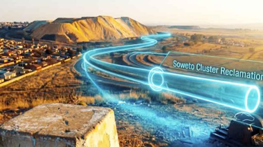
New map highlights major platinum discoveries in South Africa

WORTH A THOUSAND WORDS Oliver Barker says the maps convey information pictorially which words cannot convey
Photo by Oliver Barker
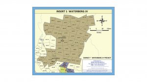


The fifth edition of Barker’s Platinum Map of Southern Africa highlights recent major platinum discoveries in South Africa – including the Waterberg and Flatreef projects – notes Banzi Geotechnics founder Oliver Barker.
He notes that the map demonstrates the massive breakthroughs in increasing South Africa’s platinum resources at shallow depths by incorporating newer discoveries.
The map, produced last year, shows the platinum mines of the western, eastern and northern belts of the Bushveld Complex, in South Africa, and the Great Dyke, in Zimbabwe.
The fifth edition of the platinum map features world supply and demand for platinum and palladium and notes on the processing of the ore to metal.
Barker and Books on the Wall Publishing’s maps have shown the geographical location of mining leases and provided a picture of the geology, the spatial relationship and ownership of mines throughout the Southern Africa region for more than 30 years.
“The maps convey information pictorially which words cannot convey,” says Barker.
He describes the maps as “invaluable”, both for the mining companies themselves that use them for public relations at presentations to shareholders and potential investors, and for exploration companies to generate optimism and raise capital by providing an indication of ‘good’ locations for exploration.
They are also frequently used for in-company education and training, in schools and in communities around the mines to show the location of the mines and explain the mining operations.
The coal maps are also particularly helpful because, on account of the competition between mining, agriculture and water and nature conservation for land in the coal-producing areas of Mpumalanga, “it is important to be able to see on a map precisely where the mining operations are situated”, Barker comments.
The twelfth edition of the coal map depicts the 19 coalfields in South Africa, including a detailed map of the mines and projects in the Waterberg coalfield. It also lists the coalfields in Botswana, Mozambique, Zimbabwe and Zambia.
The maps include plans of the coal export ports in Southern Africa: Richards Bay, Durban and East London, in South Africa; and Matola, in Mozambique.
On the platinum maps, the breakdown of platinum-group metals according to the percentages of the constituent metals is published on the basis of the prill split data from borehole and trenching samples during the exploration phase.
Barker emphasises that all the data contained on the maps is accessible in the public domain and is sanctioned by the suppliers where possible.
The maps also show reef and seam profiles, geological sections and other information relevant to the platinum and coal industries.
Books on the Wall published its seminal map on gold in 2003, which shows all the gold mines in the Witwatersrand basin and the greenstone mines of the Mpumalanga and Limpopo provinces, and compares the geological columns of the different goldfields within the basin. There is also extensive information on production by shaft.
Baker notes that, in 2018, Seriti Coal supported an update of the Main Coal Basin, which has been further revised and is now available as a specific standalone publication. “Support for the maps from the mining industry varies according to each company’s culture,” Barker says, adding that, when he decides to proceed with a specific map in a specific region, he puts out offers for sponsorship.
“Impala was the key sponsor for the platinum map update in 2018,” he comments, adding that he also received sponsorship from Sibanye-Stillwater.
Article Enquiry
Email Article
Save Article
Feedback
To advertise email advertising@creamermedia.co.za or click here
Research Reports
Projects
Latest Multimedia
Latest News
Showroom
Established on 1 March, 2000, by Barries Barnard, Advanced Fire Suppression Technologies (AFST) and the Advanced Group stands as Sub-Saharan...
VISIT SHOWROOM
Virtual Gas Network supplies compressed natural gas via a virtual gas distribution network.
VISIT SHOWROOM
Announcements
What's On
Subscribe to improve your user experience...
Option 1 (equivalent of R125 a month):
Receive a weekly copy of Creamer Media's Engineering News & Mining Weekly magazine
(print copy for those in South Africa and e-magazine for those outside of South Africa)
Receive daily email newsletters
Access to full search results
Access archive of magazine back copies
Access to Projects in Progress
Access to ONE Research Report of your choice in PDF format
Option 2 (equivalent of R375 a month):
All benefits from Option 1
PLUS
Access to Creamer Media's Research Channel Africa for ALL Research Reports, in PDF format, on various industrial and mining sectors
including Electricity; Water; Energy Transition; Hydrogen; Roads, Rail and Ports; Coal; Gold; Platinum; Battery Metals; etc.
Already a subscriber?
Forgotten your password?
Receive weekly copy of Creamer Media's Engineering News & Mining Weekly magazine (print copy for those in South Africa and e-magazine for those outside of South Africa)
➕
Recieve daily email newsletters
➕
Access to full search results
➕
Access archive of magazine back copies
➕
Access to Projects in Progress
➕
Access to ONE Research Report of your choice in PDF format
RESEARCH CHANNEL AFRICA
R4500 (equivalent of R375 a month)
SUBSCRIBEAll benefits from Option 1
➕
Access to Creamer Media's Research Channel Africa for ALL Research Reports on various industrial and mining sectors, in PDF format, including on:
Electricity
➕
Water
➕
Energy Transition
➕
Hydrogen
➕
Roads, Rail and Ports
➕
Coal
➕
Gold
➕
Platinum
➕
Battery Metals
➕
etc.
Receive all benefits from Option 1 or Option 2 delivered to numerous people at your company
➕
Multiple User names and Passwords for simultaneous log-ins
➕
Intranet integration access to all in your organisation