Photogrammetry versus LiDAR: Which Method Best Suits your Needs?


Spatial professionals rely heavily on point cloud data to conduct daily tasks whereby this data is often generated using either photogrammetry or LiDAR. Despite producing datasets which look very similar, Photogrammetry and LiDAR are in fact different. Here we unpack both Photogrammetry and LiDAR and summarise the common applications of both to help you determine which method would better suit the exact requirements of your project:
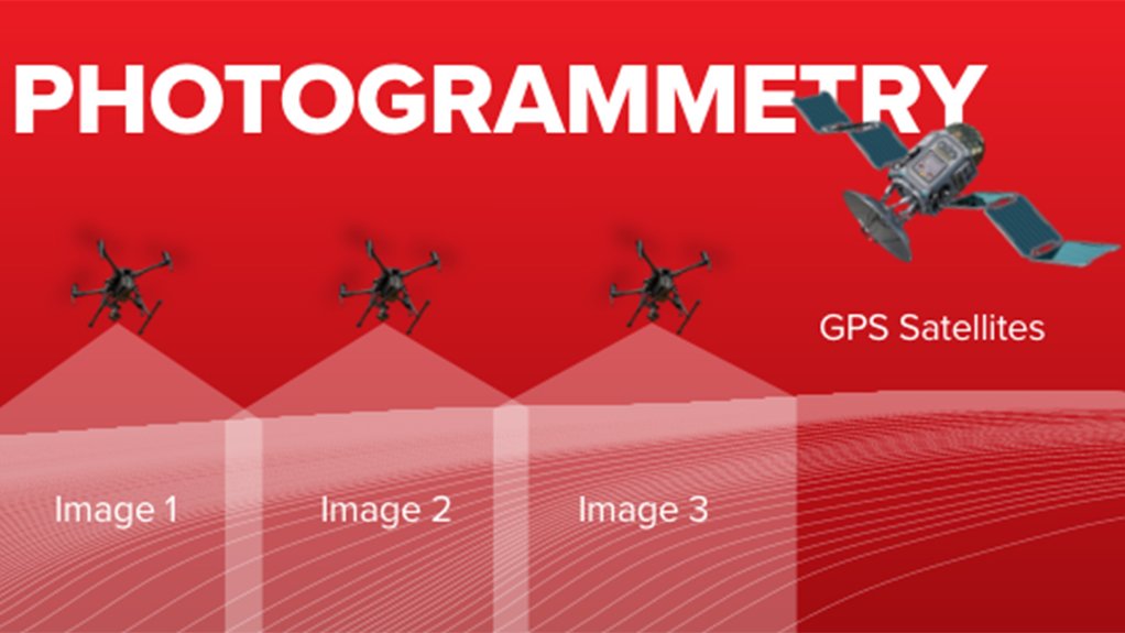
Photogrammetry Explained
Photogrammetry is a mapping technology that allows drones to capture large numbers of high-resolution images over a particular area of interest. These photos are then overlapped and the same point on the ground can be seen in multiple images from different viewpoints, resulting in point clouds containing elevation, height, shape, texture and colour. However, one of the main limitations of photogrammetry is that it requires a completely clear view of the target area being mapping.
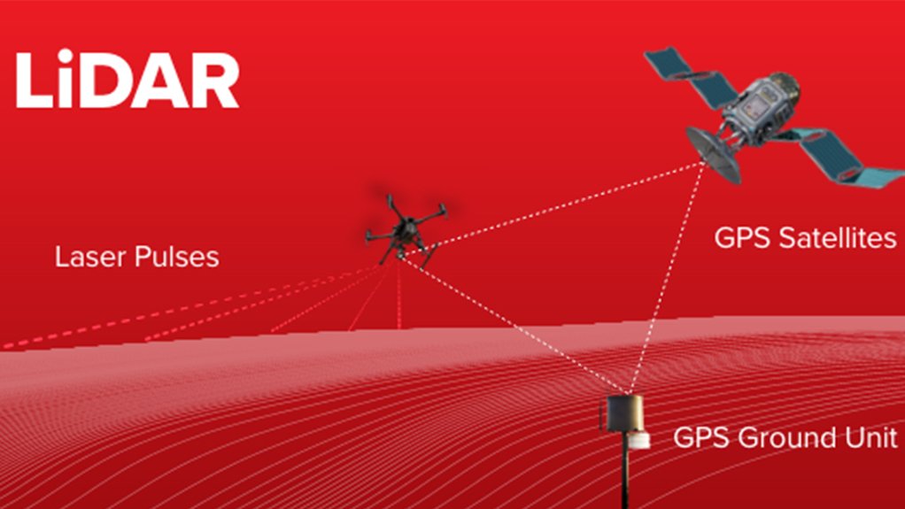
LiDAR Explained
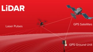
LiDAR refers to “Light Detection and Ranging” whereby scanning sensors send out laser pulses of light and measure the precise time it takes for each pulse to bounce back from the ground as they return. By measuring the intensity and timing of the returning pulses, the scanner is able to provide a reading of the points on the ground. If the position and orientation of the sensor is known, it can be combined with the pulses and return data to create a geo-referenced 3D point cloud of the terrain, vegetation or structures present in the scanned area. Furthermore, LiDAR point clouds are highly detailed, offering high data accuracies up to the millimetre level. Unlike photogrammetry, pulses can penetrate through tree canopy gaps enabling these points to be identified and classified as ground points.
Choosing between Photogrammetry and LiDAR
If your goal is to accurately survey land that is covered with a dense canopy of vegetation, LiDAR would be the best method to deliver highly detailed results as the light pulses are able to penetrate between leaves and branches. LiDAR is therefore a great option for those operating in the forestry industry as it offers the dual advantage of mapping very large tracts of trees and areas covered in dense flora or foliage. LiDAR is also very useful when it comes to accurately conducting powerline, irrigation and pipeline inspections.
However, when it comes to broader surveying requirements such as those found in the mining and construction industries, drone surveying using photogrammetry can be a far more affordable solution that still achieves great accuracy. In such cases, LiDAR is not always the best option especially due to new advances in photogrammetric surveying software, achieving the same results with equipment that is far more affordable. Photogrammetric drone data can also be used to meet varying objectives across multiple functions such as surveying stockpiles, monitoring slope stability, calculating stockpile volumes, mapping geological structures, inspecting solar panels and much more.
The Final Word
If you are looking to capture terrain data under a dense blanket of flora, calculate metrics pertaining to vegetation or obtain the catenary of high voltage powerlines, then LiDAR would be best suited for your project. Conversely, if you are mapping a wide-open area, then photogrammetry will be more than adequate for your requirements. The case for which method is best should be exclusively based on what problems you are looking to solve and what deliverables you are wanting to achieve. If you are looking to incorporate either drone photogrammetry or LiDAR into your operation contact Rocketmine today!
Article Enquiry
Email Article
Save Article
Feedback
To advertise email advertising@creamermedia.co.za or click here
Projects
Latest Multimedia

Latest News
Showroom

Industrial Nozzles & Systems (Pty) Ltd (Est. 2000) exclusive representative in Southern Africa for LECHLER GmbH (Est. 1879) - Europe's leading...
VISIT SHOWROOM
M and J Mining are leading suppliers of physical support systems as used by the underground mining industry. Our selection of products are not...
VISIT SHOWROOM


Press Office
Announcements
What's On
Subscribe to improve your user experience...
Option 1 (equivalent of R125 a month):
Receive a weekly copy of Creamer Media's Engineering News & Mining Weekly magazine
(print copy for those in South Africa and e-magazine for those outside of South Africa)
Receive daily email newsletters
Access to full search results
Access archive of magazine back copies
Access to Projects in Progress
Access to ONE Research Report of your choice in PDF format
Option 2 (equivalent of R375 a month):
All benefits from Option 1
PLUS
Access to Creamer Media's Research Channel Africa for ALL Research Reports, in PDF format, on various industrial and mining sectors
including Electricity; Water; Energy Transition; Hydrogen; Roads, Rail and Ports; Coal; Gold; Platinum; Battery Metals; etc.
Already a subscriber?
Forgotten your password?
Receive weekly copy of Creamer Media's Engineering News & Mining Weekly magazine (print copy for those in South Africa and e-magazine for those outside of South Africa)
➕
Recieve daily email newsletters
➕
Access to full search results
➕
Access archive of magazine back copies
➕
Access to Projects in Progress
➕
Access to ONE Research Report of your choice in PDF format
RESEARCH CHANNEL AFRICA
R4500 (equivalent of R375 a month)
SUBSCRIBEAll benefits from Option 1
➕
Access to Creamer Media's Research Channel Africa for ALL Research Reports on various industrial and mining sectors, in PDF format, including on:
Electricity
➕
Water
➕
Energy Transition
➕
Hydrogen
➕
Roads, Rail and Ports
➕
Coal
➕
Gold
➕
Platinum
➕
Battery Metals
➕
etc.
Receive all benefits from Option 1 or Option 2 delivered to numerous people at your company
➕
Multiple User names and Passwords for simultaneous log-ins
➕
Intranet integration access to all in your organisation