Multispectral, hyperspectral data used to assess AMD impact in Mpumalanga coalfields


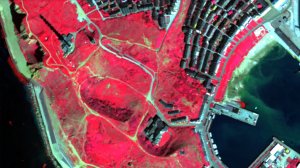
CHALLENGING EXCERCISE Identifying and mapping areas of mine pollution on the ground is a very time consuming and expensive activity
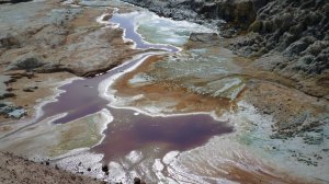
HYPERSPECTRAL IMAGING Ground verification targets were selected from the hyperspectral and multispectral data and showed about a 50% success rate
Photo by Fraunhofer Institute of Optronics, System Technologies and Image Exploitation


Acid mine drainage (AMD) has become a major environmental problem associated with mining in South Africa, affecting not only gold mines but also coal mines, says Council for Geoscience (CGS) geophysicist Janine Cole.
She explains that identifying and mapping areas of mine pollution on the ground is a time-consuming and expensive activity, and, therefore, it is desirable to find ways of narrowing down the areas where fieldwork can be focused.
Cole says that this will assist in improving the efficiency of pollution studies. She notes that, in a recent study of AMD-related pollution in the Mpumalanga coalfields undertaken by the CGS, multispectral and hyperspectral results were compared to determine whether spectral resolution and the range of multispectral data were sufficient to detect mine pollution, as well as whether hyperspectral data was essential in these type of studies.
The multispectral datasets that were used in this study included advanced spaceborne thermal emissions and reflection radiometer (Aster), RapidEye, Worldview-2 and Landsat 8 satellite imagery.
“Aster was selected because it has the most bands in the shortwave-infrared range and is widely used in geological applications. It is also not very expensive,” Cole highlights.
She adds that RapidEye and Worldview-2 satellites cover the range of wavelengths that characterise vegetation, and that their spatial resolution made them well suited for this part of the study. Further, Cole notes that Landsat 8 was used because it is freely available.
She points out that direct and indirect approaches of identifying AMD-related minerals from remote sensing data were also investigated. “It was possible to detect precipitated secondary iron-bearing minerals directly by mapping their spectral signatures, while changes in vegetation were likely to give an indirect indication of pollution.”
Cole remarks that hyperspectral data collected over two pilot areas were classified into power of hydrogen (pH) levels and provided an effective visualisation of possible AMD.
However, she comments that, owing to the limited number of bands in the multispectral datasets, the same classification method could not be applied to them and more traditional methods, such as band ratios, spectral angle mapping, matched filtering and linear spectral unmixing, had to be used.
“These techniques yielded limited success and, in many instances, vegetation was classified as AMD minerals. Since wetlands could contain AMD, vegetation was not masked but was noted.”
Additionally, Cole says that the ground verification targets were selected from the hyperspectral and multispectral data and showed about a 50% success rate.
She states that, although all the datasets were used to select target areas, the hyperspectral results definitely narrowed down the target areas and improved the success rate.
Cole emphasises that the RapidEye was “very useful” for the detection of unhealthy vegetation, whereas Aster yielded the best results for the AMD mineral classifications.
Further, she points out that digital elevation models were derived from the active remote sensing technology, light detection and ranging (Lidar) data, which were collected over the two study areas.
These areas were analysed to delineate possible sinkholes and channels that could form conduits for pollution from mining areas and possible sinkholes. For both areas, many of the sites where AMD precipitation was identified from the hyperspectral and multispectral data were located at, or close to, the ends of some of these channels.
Cole points out that the study highlighted that, although the limited band coverage and resolution of multispectral data severely affects the results of such analyses, using the results in conjunction with other criteria, such as water flow analyses and proximity to hazards would improve the results.
She says that if Lidar data is not available, digital elevation model data can still provide a sense of water flow and surface drainage and, therefore, may also assist in constraining the results.
Cole notes that the percentage of false positives when using only multispectral data will be much greater than when hyperspectral data is available. However, she stresses that, given the cost benefits of the multispectral data, these cannot be discarded.
“One of the advantages of multispectral datasets is that data can be obtained for multiple years, thereby allowing for change detection. Although this is also possible with hyperspectral data, the cost involved is prohibitive,” Cole concludes.
Cole was speaking at the recent CGS 2016 conference, which was held at the Council for Scientific and Industrial Research International Convention Centre, in Tshwane.
Article Enquiry
Email Article
Save Article
Feedback
To advertise email advertising@creamermedia.co.za or click here
Research Reports
Projects
Latest Multimedia
Latest News
Showroom
For over 60 years, VEGA has provided industry-leading products for the measurement of level, density, weight and pressure. As the inventor of the...
VISIT SHOWROOM
Goodwin Submersible Pumps Africa is sole distributors for Goodwin electrically driven, submersible, abrasion resistance slurry pumps.
VISIT SHOWROOM

Press Office
Announcements
What's On
Subscribe to improve your user experience...
Option 1 (equivalent of R125 a month):
Receive a weekly copy of Creamer Media's Engineering News & Mining Weekly magazine
(print copy for those in South Africa and e-magazine for those outside of South Africa)
Receive daily email newsletters
Access to full search results
Access archive of magazine back copies
Access to Projects in Progress
Access to ONE Research Report of your choice in PDF format
Option 2 (equivalent of R375 a month):
All benefits from Option 1
PLUS
Access to Creamer Media's Research Channel Africa for ALL Research Reports, in PDF format, on various industrial and mining sectors
including Electricity; Water; Energy Transition; Hydrogen; Roads, Rail and Ports; Coal; Gold; Platinum; Battery Metals; etc.
Already a subscriber?
Forgotten your password?
Receive weekly copy of Creamer Media's Engineering News & Mining Weekly magazine (print copy for those in South Africa and e-magazine for those outside of South Africa)
➕
Recieve daily email newsletters
➕
Access to full search results
➕
Access archive of magazine back copies
➕
Access to Projects in Progress
➕
Access to ONE Research Report of your choice in PDF format
RESEARCH CHANNEL AFRICA
R4500 (equivalent of R375 a month)
SUBSCRIBEAll benefits from Option 1
➕
Access to Creamer Media's Research Channel Africa for ALL Research Reports on various industrial and mining sectors, in PDF format, including on:
Electricity
➕
Water
➕
Energy Transition
➕
Hydrogen
➕
Roads, Rail and Ports
➕
Coal
➕
Gold
➕
Platinum
➕
Battery Metals
➕
etc.
Receive all benefits from Option 1 or Option 2 delivered to numerous people at your company
➕
Multiple User names and Passwords for simultaneous log-ins
➕
Intranet integration access to all in your organisation