A FEAST FOR THE SENSORS The Heron Lite enables easy and accurate on-foot mapping
Surveying equipment distributor Autobuild Africa launched a new mobile scanner – the Heron Lite – at the SA GeoTech 2019 conference, in Kempton Park, last month.
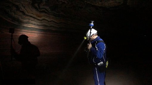
The device was developed by survey technology company Gexcel as part of its Heron range of wearable mobile mapping products.
The Heron Lite comprises a Velodyne Puck Lite sensor with an inertial measurement unit and a control unit tablet. The small, portable laser scanner weighs about 2.5 kg excluding the control tablet.
The sensor is installed on a stick or a helmet, depending on the preference of the user, and is powered by a lithium-polymer 12 V 4.5 Ah battery, which is worn on a belt.
“Normally, laser scanning means that one has to set up tripods with overlapping configurations, and then it takes a long time to do the post-processing. The Heron Lite negates this. One can walk through a mine and have all the mapping done in a day,” Autobuild Africa MD Dave Beattie tells Mining Weekly.
The device uses simultaneous localisation and mapping technology (SLAM) to deliver real-time three-dimensional (3D) mapping visualisations up to a range of 100 m with a local accuracy of up to about 3 cm.
Its applications include building information modelling, stockpile scanning, mine tunnel scanning or general tacheometry, or tachy surveys.
Scans are aligned in real time and displayed on the tablet controller to ensure that all areas are covered before leaving the site.
The Heron Lite does not allow for real-time change detection, although it does allow for change detection in post processing.
All Heron devices use a patented algorithm that reduces the drift effect common to SLAM technology through global 3D optimisation, which can improve global accuracy.