In 1986, the first-ever coalfields map was printed. Now in its 16th edition, this map has gained national and international recognition as a comprehensive source of information on the South African coal mining sector. It has a dedicated following of supporters and subscribers.
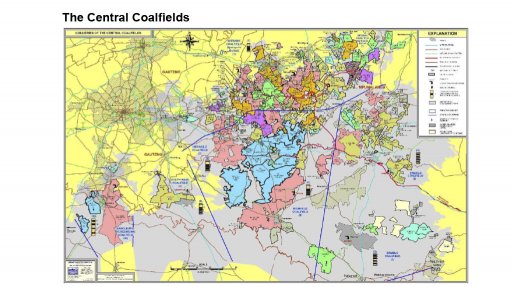
The map, created by Oliver Barker, accurately depicts the distribution of coal mine operations that source their coal from the Karoo rocks in southern Africa. It also provides valuable information from over ninety coal mines in South Africa. The map includes key export hubs such as Richards Bay Coal Terminal and Durban Coal Terminal and Matola in Mozambique, highlighting southern Africa's involvement in the international coal trade.
Coal is distributed across various regions in South Africa, playing a vital role in the country's economy and energy sector. The still operating, eighteen power stations reflect coal's significant and continued role in electricity generation.
The map details and presents coal mining companies, future projects, including confirmed and potential projects. Furthermore, it lists prominent companies in the coal industry, including Thungela Resources Ltd, Sasol Mining, Glencore Xstrata, Exxaro, and Seriti Operations. Coal mining companies in Botswana and Swaziland, are included.
Fifty-one Coalfields spread out through southern Africa, Botswana, Namibia, Zimbabwe and Mozambique are identified by number. Mining and production methods employed, and the products derived from different coal seams are listed. Trade details, such as exports and inland coal trade, are also provided by mine.
The Coalfields extend from Gauteng (Boksburg) east to beyond, Ermelo in Mpumalanga, south into the northern KwaZulu-Natal province, and southwest through the South Rand into the Free State past Sasolburg, pinching out west and south of Welkom. The limit of coal formation is marked.
Younger coal deposits are developed north of Johannesburg near (Bela-Bela (Warmbaths), in the Springbok Flats Coalfield, the Waterberg coalfield and Limpopo valley region as well as the Eastern Cape (the Molteno Coalfields).
The Witbank and Highveld Coalfields, situated in Mpumalanga Province, remain the largest coal-producing fields in the country. They are known for bituminous coal used in power generation both internally (Eskom and Sasol) and for high quality steam and metallurgical export coal.
The Ermelo Coalfield, situated in Mpumalanga Province, has historically been an important source of export coal, although production has declined over time. These days, the coalfield supports a large number of smaller producers of mainly, steam coal for local consumption but some is still exported.
The Springbok Flats coalfield lying north of Pretoria and east of Bela Bela, has large deposits of bituminous coal with a high liquefaction potential and with local Uranium concentrations. It is currently still unmined.
Waterberg Coalfield in Limpopo Province, is a developing coalfield with vast resources and the potential to become a major coal-producing region in the future, serving domestic power generation and export of a coking coal fraction. The large Grootegeluk coal mine is the only operating mine within coalfield supplying Medupi and Matimba power stations.
In KwaZulu-Natal, the main Coalfields are found around Newcastle and Dundee east to Vryheid primarily serving local demand (and minor export), for higher quality bituminous, anthracite and metallurgical coals.
The Soutpansberg-Limpopo Coalfields lie along the northern border of South Africa, extending into neighbouring Botswana and Zimbabwe. The coalfield contains coal resources that could supply both steam and metallurgical coal to the local market and for export.
The Free State Coalfield is located south of the Vaal River. The main coal-producing areas in the Free State province are centred around towns like Sasolburg and Vereeniging and are used for power stations and chemical technology (SASOL process).
Current and planned energy sources, rail and energy network are shown on a map from Eskom Holding SOC Ltd. It shows the planned green development regions spreading from the Northwest, Free State, Eastern Cape, Northern Cape down to the Western Cape.
The rail line network between the coal mines, major hubs and export facilities include both multiuse corridors as well as dedicated rail lines (Richard Bay Coal Line), facilitating the transportation of coal for export, Substantial degradation of many of these lines has led to the increasing use of diesel truck coal trains which deliver coal both inland and to the ports.
The Lephalale Coalbed Methane Project (LCBMP) belonging to Thungela Resources in the Waterberg Coalfield aims to extract coalbed methane gas from coal. The project is seen as a short-term transition to greater dependence on alternative energy sources, reducing greenhouse gas emissions and diversifying the country's energy mix. This project aims to reduce coal dependence.
A graph of coal production and export shows that between 2008 - 2022, South Africa's coal industry faced challenges and opportunities, with fluctuations in export, local consumption, production, and sales due to domestic demand, international market conditions, and policy changes.
First published in 1986, Barker’s Coalfields Map of Southern Africa (16th Edition) remains a preeminent showcase of a key driver of jobs and income to South Africa.