AIRBORNE SURVEYS Xcalibur Airborne Geophysics specialises in ultrahigh resolution magnetics, radiometrics, electromagnetics and gravity surveys
South Africa-based airborne geophysics company Xcalibur Airborne Geophysics, which will exhibit at this year’s Investing in African Mining Indaba, has been contracted to work on Angola’s National Geology Plan, the Planageo programme, which will produce credible, processed and mapped information to manage and use the country’s mineral resources.
The Planageo programme is being executed by three main contractors, and Xcalibur has been subcontracted by two of the main contractors: UTE IGME-LNEG-Impulso (a Spanish-Portuguese joint venture (JV) and Consorcio Costa Negocios-Topocart (a Brazilian JV)to perform airborne magnetics and radiometrics mapping of a target area of about 940 000 km2 in Angola.
Xcalibur representative Simon Bosch tells Mining Weekly that the company is committed to completing its Planageo commitments in the next 18 months, using its proprietary Mag-Rad fixed wing high-performance solutions (XAGMAG systems) to perform the magnetics and radiometrics surveys.
Xcalibur will place between four and five systems for the executing of the project.
Bosch also notes that Xcalibur has attended the Indaba since 2008 and that it has established new business contacts at the event each year. This year’s Investing In African Mining Indaba will be held at the Cape Town International Convention Centre from February 9 to 12.
About Xcalibur
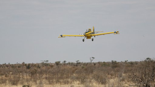
Xcalibur Airborne Geophysics specialises in ultrahigh resolution magnetics, radiometrics, electromagnetics and gravity surveys across Africa and the Middle East. The company has a fleet of aircraft comprising robust turbine Air Tractors, turbine BN-2T Islanders and Airbus Helicopter B2-B3s.
“This enables the company to collect data at a lower ground clearance than what is commonly used in the airborne survey industry – from 20 m to 40 m. Because spatial resolution and signal-to-noise ratios improve dramatically when flight altitude is reduced, data collected at low flying levels provide significantly more detailed information for kimberlite detection, base and precious metals exploration, litho-structural mapping and mine planning,” says Xcalibur.
The company further explains that the survey height is generally limited by the height of the vegetation and the presence of man-made features, such as power lines, buildings and antennae.
Xcalibur was established more than 14 years ago and has collected about 3.5-million kilometres of data at low flying levels. The company has operated in most African countries, the Middle East and in Canada. Its client base includes some major geological surveys agencies, most major mining companies and many junior exploration companies.
Xcalibur uses the Eurocopter B3 to provide high-resolution electromagnetics surveys. It also uses the Eurocopter B2 to provide helicopter Mag-Rad surveys.
Additionally, the company uses the twin- turbine Islander aircraft to provide regional gravity, magnetic and radiometric surveys.
“These aircraft can operate at low speeds and are ideal for high-resolution gravity surveys for hydrocarbon exploration over water,” Xcalibur concludes.