Name: Kibali mine.
Location: Kibali is located in the north-eastern part of the Democratic Republic of Congo (DRC), near the border between Uganda and South Sudan.
Controlling Company: Kibali Goldmines SA, a joint venture between Randgold Resources (45%), AngloGold Ashanti (45%) and DRC State-owned mining company Société Miniére de Kilo-Moto SA (Sokimo).
Randgold Resources is the operator of the mine.
Brief Description: Operations at Kibali focus on openpit and underground mining, with underground development on twin declines and a vertical shaft. Gold production began in the fourth quarter of 2013.
Brief History: On October 15, 2009, Randgold Resources acquired a 50% indirect interest in Moto Goldmines through a joint venture with AngloGold Ashanti. Moto held a 70% stake in Kibali, with the balance of 30% held by the DRC parastatal Sokimo. On December 21, 2009, Randgold and AngloGold Ashanti increased their joint venture interest in Kibali to 90%, while Sokimo retained a 10% holding.
First gold was poured in September 2013 from the openpit operations, and the twin declines and a vertical shaft have since been developed for its underground extension. Underground mining started in 2014 and the vertical shaft is expected to be completed in 2017.
Products: Gold.
Geology/Mineralisation: Kibali is located within the Moto greenstone belt, which comprises Archaean Kibalian volcano-sedimentary rocks and ironstone-chert horizons that have been metamorphosed to greenschist facies. It is cut by regional scale north-, east-, north-east and north-west-trending faults and is bounded to the north by the middle Archaean West Nile granite-gneiss complex and to the south by the Upper Zaire granitic complex.
The local geology consists of a volcano-sedimentary sequence comprising sedimentary rocks, several varieties of pyroclastic rocks, basaltic flow rocks, mafic-intermediate intrusions (dykes and sills) and intermediate-felsic intrusive rocks (stocks, dykes and sills). This sequence is variably altered from slight to intense, where, in some cases, the original lithology of the rock is unrecognisable.
Several major mineralised trends have been outlined by soil geochemistry data and the distribution of known gold mineralisation. The Kibali-Durba-Karagba trend and the Gorumbwa-Kombokolo Splay are anomalous with respect to gold endowment and together define a 1.5-km-wide and 8-km-long mineralised, north-east-striking ‘mineralised corridor’. These corridors host the Kibali, Sessenge, Gorumbwa, Karagba, Chauffeur, Durba and Pakaka deposits.
The main Kibali deposit, which consists of Karagba, Chauffeur and Durba, is colloquially termed the KCD deposit and hosts 79% of the grant’s mineral resource and 81% of the openpit and underground ore resources. The next largest deposit is Pakaka, which hosts about 6% of the mineral resource and 7% of the ore reserve. Currently, only the KCD deposit hosts an underground ore reserve and this constitutes 74% of the KCD ore reserve.
Reserves: Proven and probable reserves as at December 31, 2015, were estimated at 80-million tonnes, grading 4.1 g/t of gold for 10.6-million ounces.
Resources: Measured and indicated mineral resources as at December 31, 2015, were estimated at 134-million tonnes, grading 3.7 g/t of gold for 16-million ounces, and 47-million tonnes, grading at 2.5 g/t for 3.9-million ounces of inferred resources.
Mining Method: The project comprises openpit and underground mining, with contractors DTP Mines and Byrnecut undertaking openpit and underground mining operations respectively. Longitudinal and transverse longhole stoping methods with paste backfill are the current underground mining methods.
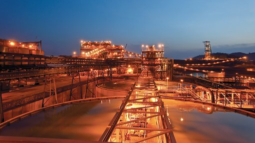
Major Infrastructure and Equipment: Surface infrastructure associated with Kibali includes a processing plant, tailings storage facilities, a camp, hydro and thermal power stations, an airstrip, workshops, laboratories and offices.
The current processing plant can treat oxide and fresh sulphide material with a nameplate capacity of 7.2-million tonnes a year, and is configured for flotation and ultrafine grind of the flotation concentrate, a treatment that is required for the sulphide ore type before leaching.
Prospects: Additional oxide sources from Kombokolo, Tete Bakangwe, Bakangwe Aval and Memekazi have been investigated for inclusion in the mine plan. Updated mineral resource models have been produced for Gorumbwa, Mengu Hill and Megi. The KCD geological model is being extensively revised following a detailed relogging exercise of historic core and integration with underground grade-control drilling and mapping. Rebuilding of lithologic, alteration and mineralisation wireframes has been completed for the 5 000 lodes.
Contact Person: Group GM for corporate communications Lois Wark.
Contact Details:
Randgold Resources,
tel + 44 1534 735 333,
email lois.wark@randgold.com, and
website http://www.randgold.com.