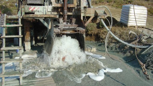
TESTING THE WATERS The project entails drilling a 3.5 km vertical borehole in the Beaufort West area to gather information on the deep Karoo Supergroup stratigraphy and hydrogeology
South Africa’s groundwater resources play a significant role in the domestic water supply and are often the sole source of water available to local municipalities and farmers in the arid Karoo basin.
The possible existence of large reserves of shale gas within the Karoo Supergroup, which covers about 65% of South Africa’s land mass, has focussed attention on the groundwater resources of the area.
Speaking at the recent 2016 Council for Geoscience (CGS) conference in Tshwane, CGS hydrogeologist Muvhuso Musetsho highlighted that one of the main concerns was the threat of contamination, or irreversible damage to groundwater resources as a result of above-ground and subsurface shale activities.
Moreover, he stated that the available information on the deep-seated shales and aquifer systems of the Karoo basin was “sparse” or only inferred data. “This limits regulatory authorities in making quantitative science-based conclusions and recommendations on the shale gas impacts in respect of the Karoo groundwater resources.”
Musetsho noted that a State-funded project was being undertaken by the CGS, which entailed drilling a 3.5 km vertical borehole in the Beaufort West area, in the Western Cape with the aim of gathering “much needed” information on the deep Karoo Supergroup stratigraphy and hydrogeology.
He explained that this study area was selected because it was considered to have a very high gas recovery potential from the carbonaceous Whitehill Formation of the Karoo Supergroup.
“This multidisciplinary study plans to determine the environmental baseline, assess the amount of recoverable shale gas, and understand the deep groundwater dynamics and quality thereof. It will also identify any possible contamination and monitor potential seismic interferences around this deep borehole,” said Musetsho.
The first phase of the hydrogeological investigation involves the establishment of a shallow groundwater baseline in a 10 km radius from the deep borehole site before drilling, followed by ongoing monitoring of water levels and quality during and after drilling activities.
Musetsho noted that this baseline information would document existing groundwater conditions of the study area from which a conceptual hydrogeological model would be developed.
He remarked that the project would also assist in proposing measures for the effective monitoring and establishment of mitigation plans for the overall protection of the water resources and users in the Karoo.
“To date, a preliminary assessment has been conducted in respect of the identification of aquifers and their yields from the existing national groundwater archive,” Musetsho stated.
This study included an examination of 68 boreholes and 28 water samples were collected for water quality analysis. The water quality results will examine the current status of the groundwater in the area. These results will be used to estimate any potential alterations that may be associated with deep borehole drilling.
“The study did not explore the potential role of shale gas, or any potential implications inherent to the exploitation of the resource for the development of renewable or other energy sources in South Africa.
“However, the results provided will certainly be useful as inputs to discussions around these issues,” Musetsho concluded.