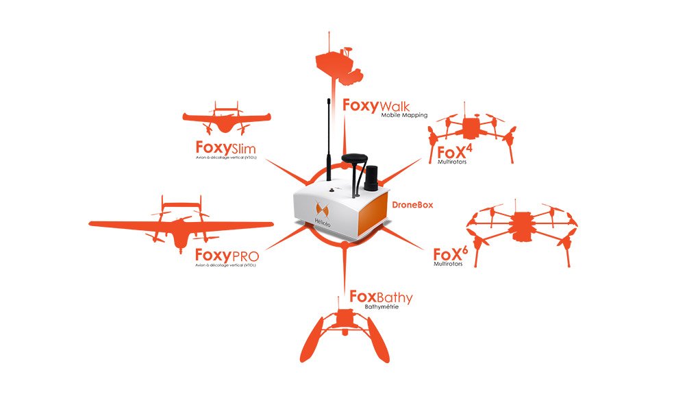
The DroneBox technology is scalable, patented, and designed to equip both plane and multi-rotor UAS, as well as terrestrial photogrammetric and bathymetric UVS. This solution is a genuine technological kernel, concentrating 70% of the drone's value. By investing in the DroneBox, professionals gain access to Hélicéo's seven measurement solutions at a reduced price.
Solutions to suit both plane and multi-rotor drones
GNSS RTK boards, autopilot, telemetry, archiving, communication, flight controller and avionics: the DroneBox RTK is a real technological concentrate, capable of detecting a 2-Euro coin at a flying height of 150 metres. The box is adaptable and can equip:
- Plane drones, with a wingspan of 1.5 to 3.5 metres, to survey up to 15 km² (flying endurance increased by 400% in comparison to multi-rotor drones). The Hélicéo's planes are capable of Vertical Take-Off and Landing (VTOL).
- Multi-rotor drones, designed to cover small and medium areas of less than 1.5 km². Their static flights perform measurement of cubic volumes, intervention in limited-space areas, indoor topographic studies, etc.
The box is equipped with 2 GNSS systems (for navigation and for Trimble RTK measurements) and with a 24-million-pixels camera, optimized by a calibration process developed by Hélicéo to correct optical aberrations of the lens. Each acquired image is thus recorded with its latitude, longitude and altitude (XYZ), allowing geo-referencing to provide, at final, 2D scaled maps or 3D Digital Terrain Models (DTM).
"The DroneBox is one of the most accurate products on the market. Road, water body, terrain… it is capable of surveying absolutely everything. It's a flying measurement tool, the 'brain' of the drone. Robotic and auto piloted, using a flight plan recorded in the DroneBox, our drones are totally automatic and allow simplification and safeguarding of piloting," explains Jean-François Baudet,
CEO of Hélicéo.
The DroneBox, for terrestrial and aquatic surveys too
The barrier-busting solution in drone technology! To overcome flight limitations such as legal constraints (especially in populated areas) or the vagaries of the weather, the DroneBox technology is compatible with the field work, thus becoming the brain for FoxyWalk. This Hélicéo terrestrial photogrammetric tool is ideal for jobs such as 1:200 topographic mapping and the measurement of facades, public spaces, urban buildings, or drains and open trenches. Without its camera, the FoxyWalk naturally becomes a GPS RTK cane.
On water, to measure depth
The RTK DroneBox also equips the FoxBathy catamaran. Designed and developed in its entirety by Hélicéo engineers, this boat records the silting up of rivers, lakes, ponds, lagoons, etc. In a record time, the FoxyBathy also maps underwater volumes in sand and gravel quarries. Thanks to the DroneBox's autopilot, the 'robot boat' does the job ten times faster than the traditional method - while keeping the surveyor safe and dry.
The DroneBox is the most cost-effective solution on the market for aerial, terrestrial and aquatic surveying work. It allows professionals to increase their productivity as well as their mission potential. In the future, it will equip tools fitted with LiDAR-type laser sensors and will be usable from moving vehicles.