Company looks back on its first decade, upbeat about future fortunes
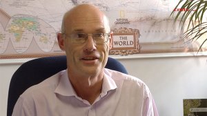
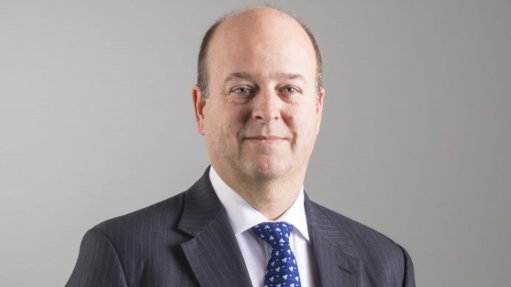
Southern Mapping CEO Norman Banks discusses the company’s achievements over its first decade of operating, and plans for the future. Camerawork: Nicholas Boyd. Editing: Lionel da Silva
HYPERSPECTRAL SURVEY Southern Mapping’s hyperspectral sensor is the only one its kind that is permanently based in Africa


South African geospatial solutions and aerial survey company Southern Mapping celebrated its tenth anniversary last month, reflecting on its many achievements while outlining its aims for the future.
“Our aim is to remain the leader in the field of aerial surveying, airborne remote sensing and continue offering innovative solutions to our clients,” asserts Southern Mapping CEO Norman Banks.
He says the company’s success is largely attributable to its having established a good record in the industry over the past ten years: “We are fortunate to have a number of loyal clients across a range of industries, including in the mining, infrastructure and agriculture sectors. We also offer a range of products and services that are suitable for clients’ needs.”
He tells Mining Weekly that the company has grown substantially from its humble beginnings. In 2006, it was leasing a single aircraft and operated one light detection and ranging (lidar) sensor. The company currently owns three aircraft, has its own aircraft maintenance and operating team, two airborne thermal cameras and four visible spectrum cameras. Southern Mapping also has three lidar sensors and is operating a hyperspectral sensor.
“Our hyperspectral sensor is the only one of its kind that is permanently based in Africa,” states Banks. He further notes that the company is an agent for handheld spectrometers and for most of the satellite data providers, including both optical and radar, in Southern Africa.
Moreover, Banks points out that the company does a lot of off-the-shelf dataset provision for clients in the early stages of project development and also undertakes a considerable amount of geological consulting work.
“Our company initially consisted primarily of surveyors. However, this has been expanded to include geographical information systems geoscientists, geologists, environmentalists and water engineers,” he highlights.
Expanding Footprint
In 2006, when the company was launched, it primarily serviced the local market. However, its customer base has expanded significantly into the rest of Africa, and currently accounts for about 70% of Southern Mapping’s total revenue generation.
The company has also worked in Yemen, France, Germany, South East Asia and South America.
Banks remarks that Southern Mapping’s primary customer base historically lay in the mining industry, comprising between 40% and 50% of its turnover. At times, the infrastructure sector has accounted for the rest of the company’s revenue stream. However, he says the infrastructure sector has taken on increased significance over the past three to five years, owing to the global downturn in the mining sector during this period.
“We have also expanded our offering into the environmental and agricultural sectors over the past five years, which currently comprises a sizeable amount of the company’s revenue,” states Banks.
Nonetheless, he emphasises that mining and infrastructure still account for the majority of the company’s total income.
Mining Sector Highlights In 2007 a mining company in the Mpumalanga coalfields, which faced a multifaceted challenge regarding on-site hydrocarbon spills and alien vegetation, contracted Southern Mapping.
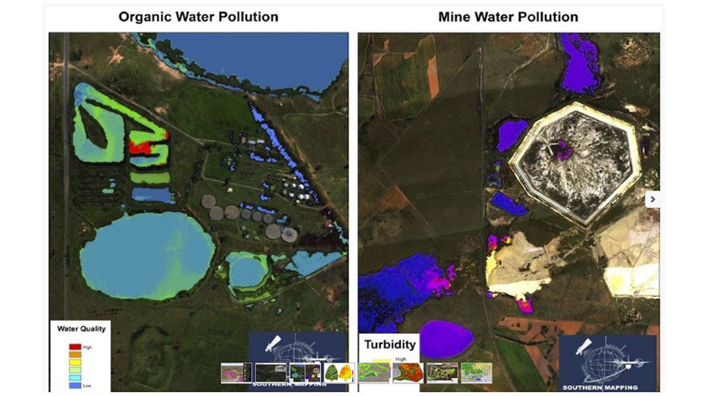
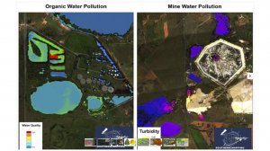
It introduced hyperspectral mapping, which the client had never used before. This technology enabled the client to examine signals beyond the visible spectrum into the infrared range of the electromagnetic spectrum, Banks elaborates.
He remarks that the amount of information that can be extracted in the near and shortwave infrared spectrum is “quite phenomenal”, allowing for hydrocarbon spills and alien vegetation, among others to be easily identified.
“We have subsequently used this hyperspectral technology for the Council for Geoscience (CGS) to help identify asbestos residue,” Banks adds.
The majority of old asbestos mines are located in the Northern Cape. Domestic production of asbestos reached 221111t/y in 1983, with about 95% of this production being exported to mostly European and East Asian countries.
South Africa had 249 known (formal and informal) asbestos mines, which posed and continue to present various problems in terms of the types of historical and current exposure to asbestos fibres.
Legislation enacted in 2008 resulted in the banning of asbestos use in all sectors, which came after the last asbestos mine had been closed in 2001. Asbestos mine rehabilitation is entirely funded by government and the current revenue for general mine rehabilitation came from a yearly budget of R50-million, as set out in the prevailing Medium-Term Budget to 2019.
Southern Mapping completed its aerial surveying work with the CGS on the asbestos site-tracking project towards the end of 2015.
Additionally, the company used hyperspectral technology for a mining company in Tete, Mozambique, in 2013. Southern Mapping conducted vegetation species and change mapping exercises while identifying several military emplacements that had previously been unknown in the area.
Other Projects
Banks points out that the company has been involved in several “memorable” nonmining-related projects.In 2009 it surveyed 244 different sites, in the Democratic Republic of Congo, for the conservation organisation World Wide Fund for Nature to assist in the carbon auditing of the country’s tropical jungle.
In 2013, Southern Mapping assisted a local university’s archaeology department in finding an extension of a Stone-Age village in Rustenburg, in the North West, which had not been previously identified, owing to dense terrain, Banks explains.
VIDEO:
To watch a video in which Southern Mapping CEO Norman Banks discusses the company’s achievements over its first decade of operating, and plans for the future, scan the barcode with your phone's QR reader, or go to Video Reports on www.miningweekly.com
Comments
Research Reports
Projects
Latest Multimedia

Latest News

Showroom
Booyco Electronics, South African pioneer of Proximity Detection Systems, offers safety solutions for underground and surface mining, quarrying,...
VISIT SHOWROOM

Press Office
Announcements
What's On
Subscribe to improve your user experience...
Option 1 (equivalent of R125 a month):
Receive a weekly copy of Creamer Media's Engineering News & Mining Weekly magazine
(print copy for those in South Africa and e-magazine for those outside of South Africa)
Receive daily email newsletters
Access to full search results
Access archive of magazine back copies
Access to Projects in Progress
Access to ONE Research Report of your choice in PDF format
Option 2 (equivalent of R375 a month):
All benefits from Option 1
PLUS
Access to Creamer Media's Research Channel Africa for ALL Research Reports, in PDF format, on various industrial and mining sectors
including Electricity; Water; Energy Transition; Hydrogen; Roads, Rail and Ports; Coal; Gold; Platinum; Battery Metals; etc.
Already a subscriber?
Forgotten your password?
Receive weekly copy of Creamer Media's Engineering News & Mining Weekly magazine (print copy for those in South Africa and e-magazine for those outside of South Africa)
➕
Recieve daily email newsletters
➕
Access to full search results
➕
Access archive of magazine back copies
➕
Access to Projects in Progress
➕
Access to ONE Research Report of your choice in PDF format
RESEARCH CHANNEL AFRICA
R4500 (equivalent of R375 a month)
SUBSCRIBEAll benefits from Option 1
➕
Access to Creamer Media's Research Channel Africa for ALL Research Reports on various industrial and mining sectors, in PDF format, including on:
Electricity
➕
Water
➕
Energy Transition
➕
Hydrogen
➕
Roads, Rail and Ports
➕
Coal
➕
Gold
➕
Platinum
➕
Battery Metals
➕
etc.
Receive all benefits from Option 1 or Option 2 delivered to numerous people at your company
➕
Multiple User names and Passwords for simultaneous log-ins
➕
Intranet integration access to all in your organisation